| Contact |
Marcos Luna
|
|---|


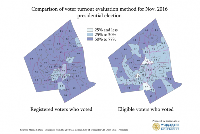
A recent report by researchers at Worcester State University (WSU) finds that voter turnout is much worse than has been reported by city and state officials. This is because voter participation is normally reported as the percentage of registered voters who voted. But many people who are eligible to vote are not registered. If eligible voters are included in the calculation of voter participation, the situation is alarming. Equally worrisome is the fact that precincts with lower voter registration are also the most underrepresented, typically minority and lower income communities. This research adds pressure to calls for more proactive voter registration processes, such as automatic voter registration. The findings of the WSU study were based in large part on the use of spatial analyses and geospatial technology.
John Holbrook, a geoscience laboratory technician in the Earth, Environment and Physics Department at WSU, and one of the co-authors of the study, is also a student in Salem State's Master of Science in Geo-Information Science program. Indeed, according to John, he secured that position because of what he has learned while in the MS Geo-Information Science program. His application of geospatial skills to the WSU study, “Eligible Voters in Worcester, Massachusetts,” has been crucial to its success and impact. The work has been featured in regional newspapers and periodicals, such as the Worcester Telegram and Worcester Magazine, and John's maps and spatial analysis have drawn much of the attention. The application of cutting edge technology to real world issues is what drew John into the geo-information science field (as well as a love of maps!). John says his long term goal is to "use my GIS training to help environmental advocacy groups, private consulting firms, and governments make informed policy decisions." It would appear that he is well on his way to doing just that.
The Geo-Information Science graduate program at Salem State University is one of the preeminent geo-information science programs in Massachusetts and New England. Established in 1993, it was the first master’s program in GIS in the United States and continues to be a leader in training GIS professionals.
