| Contact |
Stephen Young
|
|---|
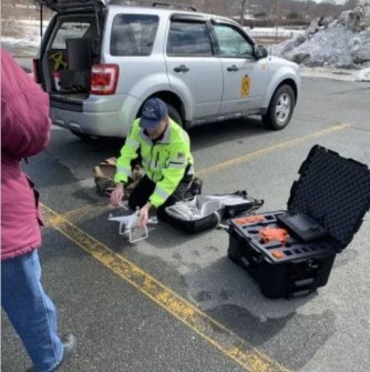
While (most) everyone at Salem State was away for spring break, geography Professor Stephen Young co-led a workshop on the use of drones or Unmanned Aerial Vehicles (UAVs) for local businesses and government agencies. His co-leaders were GIS Professional and Salem State alum Richard Ames, as well as Peabody Police Sgt. Christos Zamakis, who is currently pursuing a master’s degree in Salem State University's graduate geo-information science program.
This was the second such workshop that Salem State's geography department has hosted and it was filled to capacity. During the workshop participants learned about the current uses of drones for municipalities, how public safety departments and public works professionals can use drones, the different drone models currently available, software to fly drones within Federal Aviation Administration (FAA) requirements, how to obtain a remote pilot’s license, how to acquire proper insurance, and how to set up a drone project and fly a drone.
Gloucester Police Chief John McCarthy described the training as "comprehensive" and said, "we greatly appreciate Salem State’s work in offering this workshop to support municipalities as we navigate this complex, new territory...Drones may become an invaluable resource to the city of Gloucester in the future, and it was great to give members of the police and fire departments the chance to expand their knowledge and gain some experience with these devices.”
Drones/UAVs represent a new advancement in the geospatial field known as "remote sensing," which includes imagery collected from conventional aircraft as well as orbiting satellites. Because of drone technology's importance to the rapidly evolving geospatial field, beginning in Fall 2019, the geography department at Salem State will offer the course GPH343 Drones and Aerial Imagery Applications and Image Analysis in which students will learn how to fly drones, and how to acquire, analyze, and present the data collected.